How Flight Tracking Apps & Sites Actually Work?
Flight tracking isn’t magic, it’s a fusion of satellites, radar, ATC feeds, and thousands of volunteers. Platforms like WhereFlight turn these signals into smooth, real-time maps, making the skies accessible for passengers, parents, spotters, and researchers alike.
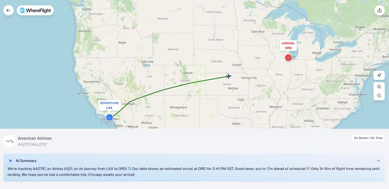
Picture this: you’re curled up on your couch, sipping your third cup of coffee, and suddenly remember that your friend’s flight just left New York. You open your phone, tap a few buttons, and boom, you can see their plane cruising at 35,000 feet over the Atlantic, zig-zagging its way to London. Pretty neat, right? But how does your phone magically know all of this? Are planes secretly broadcasting their location like tiny spy drones? Not exactly, but it’s pretty close.
Flight tracking apps and websites, like WhereFlight, have turned aviation into a live, interactive map for everyone. And while it might feel like wizardry, there’s a fascinating mix of technology, data, and good old-fashioned volunteer enthusiasm making it possible. Let’s dive into how all those flying dots appear, move, and sometimes even disappear.
The Heartbeat of Flight Tracking: ADS-B
First, meet ADS-B, which stands for Automatic Dependent Surveillance-Broadcast. Think of it as a plane constantly tweeting: “Hey, I’m here, flying at 37,000 feet, heading 270 degrees, and I’m going 560 mph.” And just like Twitter, it broadcasts this info every second or so, but only to the right audience.
ADS-B is installed in almost every modern commercial aircraft. It tells anyone with a compatible receiver where the plane is, how fast it’s going, and its altitude. Unlike traditional radar, which waits to ping a plane to know where it is, ADS-B is continuous and precise.
And that’s why your flight tracking app can give you live updates without lag. Platforms like Flightradar24 rely heavily on ADS-B signals because they’re the most reliable way to know what a plane is doing in real time.
But Wait… What About Planes in the Middle of Nowhere?
Here’s the thing: ADS-B is fantastic over cities, airports, and areas with lots of ground stations. But what happens when a plane is flying over the Pacific Ocean, a desert in Australia, or the Arctic tundra? Ground receivers are few and far between.
Enter satellite-based ADS-B. Satellites equipped with ADS-B receivers can “listen” to planes broadcasting thousands of feet below them. So even the lonely Air India flight somewhere over the Indian Ocean isn’t invisible.
Then there’s MLAT (Multilateration). If a plane isn’t broadcasting its exact GPS position, platforms can triangulate its location by analyzing signals received at multiple ground stations. It’s not perfect, it’s like trying to figure out where your lost friend is by seeing when they text you from different Wi-Fi spots, but it works surprisingly well.
And for flights in ultra-remote areas, flight trackers sometimes combine ADS-B, MLAT, and ADS-C, a contract-based system used for long-haul and oceanic flights. ADS-C is like a pre-agreed texting schedule with air traffic control: “Here’s my position every 10 minutes.” Combine all three, and your map can stay updated almost anywhere on Earth.
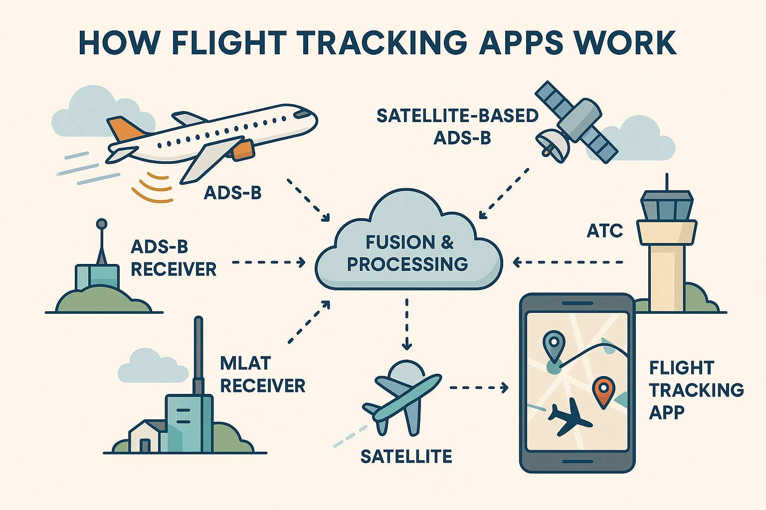
Radar, ATC, and Crowdsourced Magic
Before ADS-B, radar ruled the skies. Primary radar bounces a signal off a plane, while secondary radar communicates with the plane’s transponder. Even today, radar still plays a role, especially in areas with patchy ADS-B coverage.
Flight trackers also tap air traffic control (ATC) feeds to enrich their data. These include flight plans, estimated arrival times, and routing info. While ATC feeds don’t provide exact positions like ADS-B, they help platforms fill in gaps, especially for departures and landings.
And then there’s the magic of crowdsourcing. Aviation enthusiasts worldwide install ADS-B receivers at their homes and feed the data to platforms. Thousands of volunteers collectively become an invisible global tracking network. FlightAware, for instance, merges this volunteer network with its own tech and data feeds to ensure coverage is both wide and accurate.
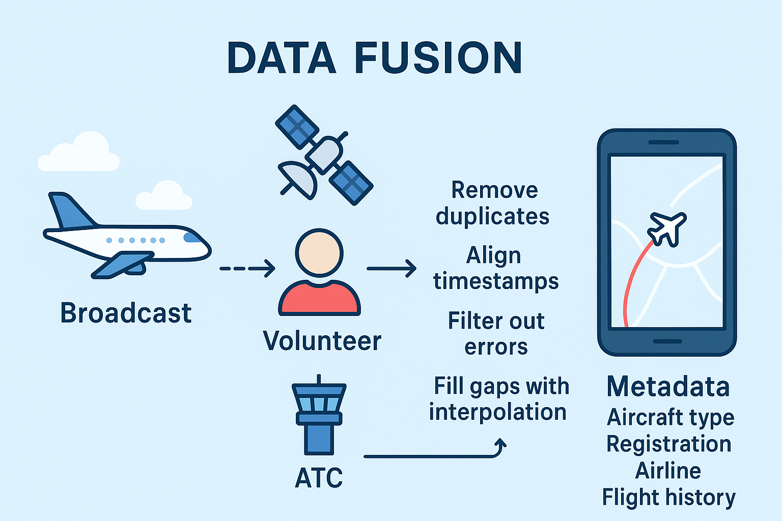
Data Fusion: Turning Signals into a Map
So, your plane is broadcasting, satellites are listening, volunteers are feeding in data, and ATC is whispering in the corner. How does all of this chaos turn into the smooth, live map you see on your phone?
This is where data fusion comes in. Flight Tracking platforms take all these streams and:
• Remove duplicates (because multiple receivers probably saw the same broadcast)
• Align timestamps (to ensure the plane isn’t jumping around)
• Filter out errors (no one wants a plane showing up 20,000 feet underground)
• Fill gaps with interpolation (estimating positions when a signal drops)
• Attach metadata like aircraft type, registration, airline, and historical flight info
In short, data fusion is the art and science of turning hundreds of messy data points into a single, smooth flight path.
Why Planes Sometimes Vanish From Your Map
Ever tracked a flight and suddenly "poof" it disappears? Don’t panic. Several things could be happening:
- No ADS-B signal: Older or private planes may not broadcast continuously.
- Privacy blocks: Military, government, or VIP flights may be deliberately hidden for security reasons.
- MLAT gaps: If triangulation isn’t possible due to a lack of ground stations, the plane may temporarily vanish.
- Satellite latency: Even satellites might take a few seconds to update signals.
Flight tracking platforms manage these gaps by showing a last known position or estimated trajectory, so the plane doesn’t feel lost entirely.
It’s Not Just About Seeing Planes, It’s About Understanding Them
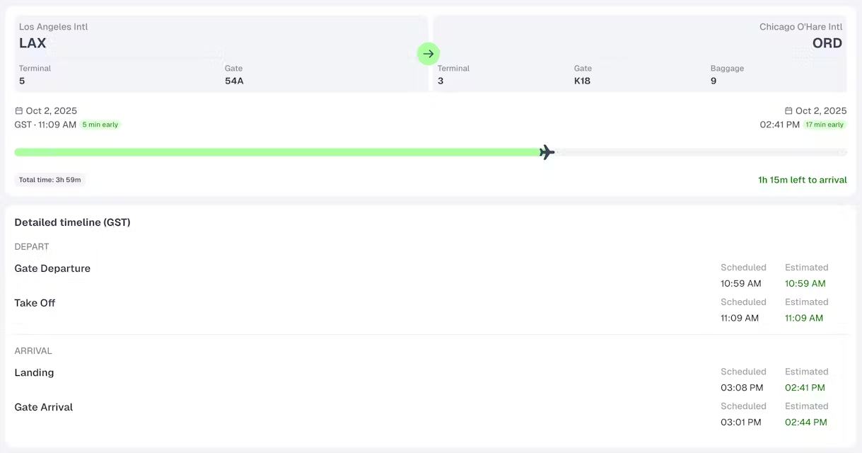
Tracking a plane is fun, but tracking the aviation ecosystem is even better. A flight tracker doesn’t just show a moving dot, it tells you:
- Which gate will be used by the airline
- Delays caused by weather or congestion
- Route history and aircraft age
- Operational patterns for airlines and airports
This is why flight tracking is a favorite tool not just for curious passengers, but also for aviation enthusiasts, journalists, and even airline operations teams.
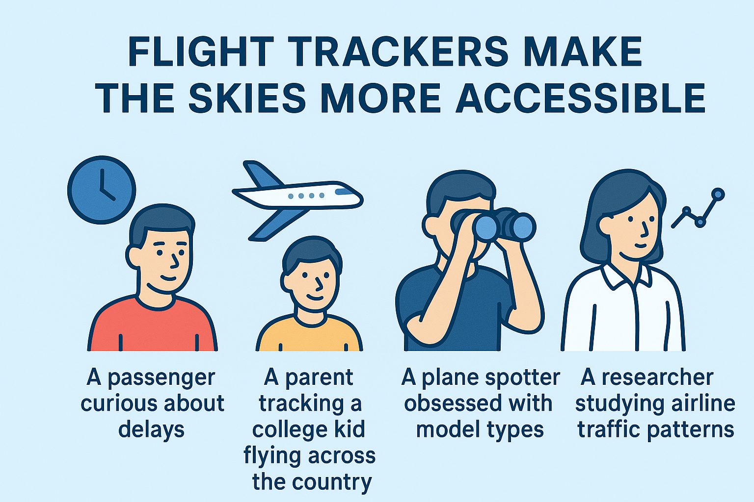
Flight Tracking for Everyone
Whether you’re:
- A passenger curious about delays
- A parent tracking a college kid flying across the country
- A plane spotter obsessed with model types
- A researcher studying airline traffic patterns
…flight trackers make the skies more accessible. Platforms like WhereFlight cater to all audiences, making sure casual users aren’t overwhelmed, while aviation enthusiasts can dig deep.
The Future of Flight Tracking
The skies are getting busier, and technology is keeping up:
- AI Predictive Analytics: Modern trackers might soon predict arrivals and delays using speed, altitude, weather, and historical trends.
- Global Satellite Coverage: More satellites mean better oceanic and polar tracking.
- Real-time Weather & Turbulence Data: Some apps overlay live weather on maps to show why that flight zigged and zagged.
- 4D Trajectories: Future apps may display flight paths including altitude, speed, and time, giving a truly interactive experience.
WhereFlight is already experimenting with richer AI contextual info, making it easier to go through the important data, saving time.
Conclusion: Why Flight Tracking Is Magical
Flight tracking apps might seem like magic at first glance, but it’s really the culmination of decades of aviation tech, satellites, community effort, and smart algorithms. Every moving dot represents a plane, a pilot, a crew, and a story. Every update on a flight tracking app map is the product of thousands of moving pieces working in harmony.
So next time you see that plane slowly cruising across your screen, remember: you’re seeing a tiny miracle of technology, collaboration, and data come alive, without ever leaving your couch. And if you’re feeling extra nerdy, you can follow it, track its route, check its aircraft type, and marvel at just how connected our skies really are.
Because in the end, flight tracking isn’t just about planes, it’s about connecting people, understanding our world, and watching the sky in real time.


Comments ()